 Snowy Ridge Classic
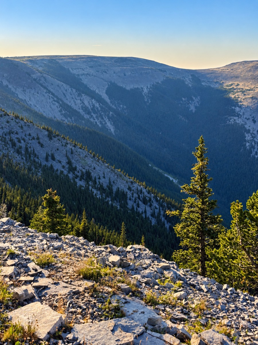
The race begins and ends on the same private property, with access granted exclusively for this event. From there, the course travels primarily through the Helena–Lewis and Clark National Forest, entering two Wilderness Study Areas and incorporating trailheads managed by the Bureau of Land Management. The course follows one expansive loop, with a smaller loop and two out-and-back sections along the way.
The course traverses the full length of both major ridgelines, climbing in and out of the high country through deep mountain drainages. The southernmost sub-ridgelines and a network of lowline trails round out an extensive exploration of the range. On the north side, trail corridors offer some of Montana's finest, least-trafficked singletrack, winding through remote drainages and heavily timbered mountainsides.
What's underfoot
Percentages are approximate.
1The Ranch Lands to West Peak
The Snowy Ridge Classic begins where the mountains meet the prairie, on the working ranchlands of Central Montana. Our race start partners, the Butcher and Miller families, have collaborated with race organizers to accommodate the starting line and start/finish line festivities, welcoming runners to a landscape shaped by people who have lived and worked this land for generations.
The opening mile travels the last bit of county road you drove in on, entering the ranch lands and transitioning from the foothills to the mountains ahead. This stretch is open to the public exclusively for the race. As the terrain grows more rugged, runners leave the private ranch lands behind and enter the National Forest at Dry Pole Canyon.
Here, the wide-open ranch lands give way to timbered drainages and narrow singletrack. The route follows the canyon floor, winding through the drainage beneath steep walls. From there, runners begin an early, steady grind toward Logan Ridge. Near mile 8, runners reach the Dry Pole Creek and Logan Ridge junction, the headwaters of Buffalo Creek.
As runners reach the Big Snowies' main ridge, just below 8,000 feet, the terrain changes once again. The climb gives way to high-elevation travel near timberline, where the trail alternates between subalpine forest and open alpine terrain. At approximately 8,200 feet, runners arrive at West Peak Aid Station near the Grandview Trail intersection. Twelve miles into the race, they've already climbed approximately 3,800 feet. And the journey across the Big Snowy Mountains has only begun.
2West Peak to Halfmoon
Leaving West Peak Aid Station, runners continue east along the backbone of the Big Snowy Mountains, beginning an approximately eight-mile traverse of the range's sweeping ridgeline. Along this stretch, runners pass the Ice Caves Trailhead along with the Western Uhlhorn Trailhead corridor, then stay high and continue east along the ridge.
The landscape alternates between timbered forests, exposed ridgelines, rocky terrain, and stretches of narrow singletrack. At times, the trail becomes faint or disappears entirely, leaving runners to follow the natural contours of the ridge. The route offers an increasingly remote experience as runners travel deeper into the heart of the mountain range, far removed from roads and developed areas.
Approaching the eastern end of the traverse, runners encounter Knife Blade Ridge, a narrow section of ridgeline that provides one of the course's most distinctive high-country features. Beyond Knife Blade Ridge, the course begins descending toward Halfmoon Pass and the Swimming Woman Basin. Sections of established singletrack give way to approximately 1.5 miles of less-defined trail, where livestock and elk use, along with natural erosion, have altered the original tread.
Halfmoon Pass is nestled in the saddle between the two high points of the range: Greathouse Peak and Old Baldy Peak. Here lies Halfmoon Aid Station at approximately mile 23. By now, runners will have traveled across the majority of the main ridgeline, experiencing some of the most remote terrain of the opening quarter of the race.
3Halfmoon Pass to Uhlhorn
Leaving Halfmoon Aid Station, runners begin their descent from the high country into the Halfmoon drainage. The opening descent drops approximately 400 feet through technical mountain terrain before gradually transitioning into open meadows and grassy trail corridors.
As the route continues east, the exposed ridgelines and rocky terrain of the previous miles give way to sheltered drainages, mountain meadows, and stretches of singletrack winding through the canyon. The trail remains technical in places, with intermittent overgrown sections, uneven footing, and numerous creek crossings. Water flows through the canyon at several points, offering opportunities to filter and refill along the way. With a filtration flask on the mandatory gear list, runners can take advantage of these natural water sources and give our pack horses a little less to carry.
As runners approach the National Forest boundary, the route makes a pronounced turn and begins a short climb of approximately 150 feet. The final mile carries runners out of the canyon and toward Uhlhorn Trailhead, where they arrive at Uhlhorn Aid Station near mile 30. A slight reprieve, as runner crews will be staged and awaiting their runners. But the eastern alpine ridge still lies ahead.
4Uhlhorn to Lost Peak
Leaving Uhlhorn Aid Station, runners turn back toward the mountains and enter the crux of the Snowy Ridge Classic. Uhlhorn 1 marks the first crew-accessible aid station of the race, offering runners an opportunity to connect with their support crews and resupply before entering the most demanding stretch of the course.
The route immediately begins climbing a rugged, locally established trail toward Maynard Ridge. Over the next 2.5 miles, runners gain substantial elevation while navigating steep mountain terrain along a route that has never been developed into a maintained trail. Upon reaching Maynard Ridge, the course intersects the Maynard Jeep Trail and turns west, continuing its ascent toward the highest elevations of the Big Snowy Mountains.
As runners approach timberline, the trail becomes increasingly faint. The forest gradually gives way to open slopes, scattered rock, and expansive alpine terrain. Here, the route leaves established tread behind and follows the natural contours of the mountain toward Old Baldy. Approximately 6.5 miles after leaving Uhlhorn, runners reach the summit of Old Baldy at roughly 8,680 feet, the highest point on the course.
From the summit, the route follows the broad alpine ridge southeast toward Lost Peak. This exposed stretch offers little shelter from the elements. Wind, sudden storms, and rapidly changing mountain weather are all part of the reality of traveling through this high country. Continuing beyond Lost Peak, the course gradually returns toward timberline, joins Big Snowy Trail #650, and begins a sustained descent of approximately four miles through the forest toward Red Hill Road.
At approximately mile 44.5, runners arrive at Lost Peak Aid Station, completing a demanding 14.5-mile journey through some of the most isolated and challenging terrain of the race. The combination of sustained climbing, high-elevation exposure, rugged footing, and limited access makes this the defining backcountry challenge of the Snowy Ridge Classic.
5Lost Peak to Uhlhorn 2
Leaving Lost Peak Aid Station, runners transition from rugged mountain trails once again, this time onto Red Hill Road, a gravel county road winding through the eastern foothills of the Big Snowy Mountains. While yet another section of technical alpine terrain is now behind them, the mountains never really let up. The road follows the natural contours of the landscape, with rolling climbs and descents that continue to demand effort from already tired legs.
The surrounding country opens up, offering expansive views of the mountains and valley flat that define this isolated range. After over 45 miles of climbing, descending, and navigating remote terrain, even the more forgiving footing of a hilly gravel road may offer little relief.
At approximately mile 52, runners return to Uhlhorn Aid Station for their second and final visit. This marks an important milestone: runners have completed the eastern alpine traverse, but another crossing of the Big Snowy Mountains still lies ahead.
6Uhlhorn 2 to Halfmoon 2
With more than half the race still ahead, runners leave Uhlhorn 2 and turn west toward the Big Snowy Mountains. Uhlhorn 2 marks the beginning of pacer access. From this point forward, runners may pick up or drop off an authorized pacer only at designated crew-accessible aid stations.
A headlamp and backup light or batteries are required equipment for all runners and pacers departing Uhlhorn 2, as the course transitions into the evening and nighttime hours.
Runners retrace their route toward Halfmoon Pass, descending into Halfmoon Creek before following the same winding singletrack and grassy trail corridors uphill toward the pass. Numerous creek crossings, uneven footing, and intermittent overgrown sections demand continued attention as the route climbs through the canyon. The final approach brings runners back to Ballard's Horse Camp and Halfmoon Aid Station. At approximately mile 59, they arrive at Halfmoon for the second time, preparing for another journey along the dark, timbered lowline trails of the Big Snowy Mountains.
7Halfmoon 2 to Timber Creek
Leaving Halfmoon Aid Station for the final time, runners head west into the darkness, beginning their journey along the lower trails of the Big Snowy Mountains. The route follows approximately 1.5 miles of familiar uneven, vegged-out mountain terrain before reaching the Swimming Woman intersection, where runners turn south and begin descending into the Swimming Woman drainage.
The upper portion of the descent follows rugged singletrack through timbered slopes and mountain meadows. Sections of trail are narrow, uneven, and intermittently overgrown, with livestock use adding to the challenge. As runners descend farther, the trail gradually widens into established two-track. Several creek crossings punctuate the descent as the course continues toward the southern foothills.
Approximately five miles after leaving Halfmoon, runners reach the junction with Careless Creek ATV Trail #652, where the route makes a pronounced turn west. A self-serve water station will be located at this junction. From here, the course follows approximately nine miles of winding ATV trails and two-track nestled beneath the main ridgeline. The terrain is characterized by repeated climbs and descents over smaller sub-ridges, alternating between timbered corridors and open mountain slopes. Fences and gates mark portions of this working landscape, where grazing and recreation have long shared the mountain foothills.
At approximately mile 73, runners arrive at Timber Creek Aid Station, completing a demanding 13.5-mile section through the southern reaches of the Big Snowy Mountains.
8Timber Creek to West Peak 2
Leaving Timber Creek Aid Station, runners continue west along the southern slopes, following a combination of established two-track and ATV trails through timbered corridors and open mountain meadows. The route continues to rise and fall across the foothills, offering little opportunity to settle into a sustained rhythm.
Approximately five miles after leaving Timber Creek, runners reach the Neil Creek Trail junction. Here, the character of the course changes dramatically. The route turns uphill and begins one of the steepest sustained climbs of the Snowy Ridge Classic, gaining approximately 2,300 feet of elevation in just over 2.5 miles. The trail narrows to singletrack as runners climb toward the Neil Creek sub-ridge, working their way through steep, timbered mountain slopes toward the crest of the range.
Near the top of the climb, runners approach the locally well-known Ice Caves, a distinctive landmark tucked into the high country near the main ridgeline. After gaining the ridge, the route follows less than one mile of familiar high-elevation trail toward West Peak 2 Aid Station. At approximately mile 81.25, runners arrive at West Peak for their second and final visit. With the long climb behind them, the final chapters of the Snowy Ridge Classic are beginning to unfold.
9West Peak 2 to Crystal Lake
Leaving West Peak Aid Station for the final time, runners begin their descent from the main ridge toward Crystal Lake, following Grandview Trail north into the heart of the Rock Creek Basin. After the demanding climb from Timber Creek, the terrain offers a welcome change in character: rugged high-country trails give way to well-established singletrack winding through the upper slopes of the main ridge.
The route initially follows a short ridgeline traverse just below timberline, offering expansive views of Crystal Lake and the towering rock formations of Grandview. For many runners, this stretch will arrive with the midmorning light, revealing a landscape that had remained mostly hidden throughout the night. The trail then begins a sustained descent through a series of sweeping switchbacks, passing near Grandview Point before dropping into the forested slopes surrounding Crystal Lake. This is some of the finest established singletrack on the course, though rocky sections and sustained downhill demand attention with more than 80 miles in the legs.
At the bottom of Grandview Trail, runners join the Crystal Lake Loop Trail and travel counterclockwise around the lake. Pay close attention to course markings through the Crystal Lake trail system. A handful of trail junctions occur in this area, including intersections runners will encounter again a few miles later. At two locations, runners may meet others traveling different portions of the course. In addition to flagging, clear directional signs and arrows will mark the route through these intersections.
At approximately mile 88, runners arrive at Crystal Lake Aid Station near the established day-use area. The station will be a lively and welcoming stop, with volunteers and supporters bringing energy just above the lakeshore.
10Crystal Lake to Cascades
Leaving Crystal Lake Aid Station, runners continue counterclockwise on the Crystal Lake Loop Trail, headed north. They pass the boat ramp before the trail turns south toward the Grandview Trail corridor. By this point, runners have completed a full circumnavigation of Crystal Lake, returning to a familiar junction with two switchbacks, clear directional signage, and well-placed course flagging. This time, the course takes them in a different direction, away from the lake.
As runners climb away from the shoreline, the trail sidehills beneath the craggy Grandview Cliffs and passes along the outer edges of the Crystal Lake Campground, where runners may once again encounter others traveling different portions of the race. The course then joins the western Uhlhorn Trail corridor and begins the final significant sustained climb of the race: approximately 800 feet over the next mile through two long switchbacks. After nearly 90 miles, this final climb offers one last reminder that the Big Snowy Mountains are not finished with you.
At the next trail junction, runners turn toward Crystal Cascades. Pay close attention to course markings here. The route crosses a mountain drainage before entering the Crystal Cascades trail system, where runners make a short out-and-back to a viewpoint overlooking the waterfall.
At the Crystal Cascades waterfall, runners collect their finisher buckles from a bear-safe cooler, our little twist to ensure everyone completes the out-and-back. With approximately seven miles to go, runners must carry their buckles themselves; pacers may not carry them. Only official finishers within the 36-hour cutoff may keep their buckles.
After returning to the junction, the course continues north toward Crystal Cascades Trailhead. The final descent begins on narrow, technical singletrack through timbered slopes and intermittent overgrowth, with several shallow creek crossings. Although the route trends downhill, the rugged terrain makes this a comparatively slow section. At approximately mile 96, runners arrive at Cascades Aid Station, the final aid station of the Snowy Ridge Classic.
11Cascades to Finish
Leaving the final aid station at Cascades, runners follow Crystal Lake Road downhill on asphalt toward the bottom of the Rock Creek drainage. After crossing the bridge, the road becomes gravel for the final two and a half miles.
Runners continue along the road, passing the same starting gate where their journey began approximately one hundred miles earlier. From here, the course enters the Butcher Family Ranch property for the final approach to the finish line. Finishing off what is sure to be a life experience unlike anything you expected.